

Weekends are usually boring! You get up, stay in bed, eat, watch a movie then the last thing you know its already evening and you realize how meaningless your day has been. But it is the only time of the week that you can get some rest and relax away from the office, so why not make the best for it? For a change, try mountain climbing! It is good for your health, magnificent view of the mountain and a good way to unwind with your friends. It really is worth the effort! Here’s a list of the best mountains you can try:
1. Broga Hill

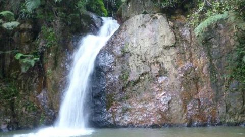
Broga Hill is also known more locally as “Bukit Lalang” which is the name of the grass that grows in the area. The hill entrance is near a palm oil plantation and rabbit farm. Using Google Maps it wasn’t that difficult to find. It is a series of 3 hills or peaks with the 2nd peak being the one that is most popular for viewing the sunrise early in the morning. The hill starts with more of a jungle walk but quickly turns into a steep, uncovered incline that works the leg muscles! The intensity of the climb can come on fast so be prepared with water and stretched muscles! The steep and exhausting incline may be why most enjoy doing this early as the late morning/afternoon heat can make the climb more challenging and tiring.
At its highest point, Broga hill stands at around 400m and can be reached from the city in about 45 minutes. It was busy on the weekend when I went and full of local, avid hikers who were out to enjoy the morning views. There are various stalls near the entrance selling water and local snacks so you can easily hydrate and eat if you are hungry before or after coming back down.
Heigth: 400m
GPS Coordinates: 2.938398, 101.901086
Fees: RM2/parking vehicle
Difficulty: Easy
Approximate hike time: 2 to 2.5 hours
2. Tabur Hill

Bukit Tabur East is the sister to Tabur West and is more difficult generally because there are less hikers climbing and so the trail is a less traveled. The main difference between both hikes is the end point. Tabur East ends with a very steep cliff that is not for the faint of heart! Be careful if you are walking in this area and venturing for a popular cliff-side photograph.
Bukit Tabur West is the more common hiking trail and is known as the “Dragon’s Backbone” and offers some great views. The trail can be a bit precarious because of the rocky terrain and there are some technical spots to the climb that may be difficult for anyone with fear of heights or lack of climbing experience. The initial ascent is short but intense and the majority of the hike consists of trekking along the ridge of the hill. On a clear day you can see Genting Highlands on one side and the KL skyline on the other including the famous twin towers.
Height: 446m
GPS Coordinates: 3.232645, 101.749899
Fees: NIL
Difficulty: Moderate (Tactical)
Approximate hike time: 2.5 to 3.5 hours
3. Gasing Hill

Bukit Gasing means “Top Hill” and at its highest point reaches 160meters. In relation to other hills in Kuala Lumpur, it is quite a small hill but it has some fairly steep inclines that will get the heart pumping. If you are training for larger hills this is a great place to start! We had a great morning hiking around this hill. There are ample rest stops and view points and you get a really nice view of Petaling Jaya at a few points as well. There are lots of hikers out on weekends and public holidays and the whole scene was positive with lots of people who love being active! Definitely worth checking it out.
Height: 160m
GPS Coordinates: 3.095232, 101.656228
Fees: NIL
Difficulty: Easy
Approximate hike time: 1 to 2.5 hours
4. Forest Research Institute Malaysia (FRIM)

FRIM is an area open to the public for a small fee for various activities like jogging, hiking, cycling or just having a picnic. There are several trails within FRIM with one of the more popular ones being the Rover Track which leads towards the Canopy Walk. An additional fee is charged for the Canopy Walk and tickets can be bought at the One Stop Centre before you begin your hike.
The trails at FRIM are not steep and the path is well marked offering an experience for beginners, children, and families. There are limited spots for the canopy walk so make sure you get in early! Other activities that you can do at FRIM include: having lunch at one of the waterfall streams, or hire a nature guide to bring you around the forest and learn in detail about the various flora and fauna.
Height: 215m
GPS Coordinates: 3.236079, 101.634778
Fees: Entrance – RM1.05/Malaysian & RM5.30/Non Malaysian | Car Entry – RM5.30 | Canopy walk – RM5/Malaysian & RM20/Non-Malaysian
Difficulty: Easy to moderate
Approximate hike time: 1 to 2 hours
5. Ayer Hitam Forest Reserve

This hidden gem is a lesser known hill even to frequent hikers in Puchong. The hill is located in a forest reserve which is jointly managed by the Forestry Ministry and UPM. This forest reserve is considered private property but the trail is commonly hiked by the local residents from the area.
However, the trail from the peak leading towards the waterfall is out of bounds. An official permit can be applied via the Official UPM Ranger Office at Taman Saujana Puchong (Jalan SP 10/13). The entire route is one big circle so whether you take the left or right when you reach a fork in your path; you will reach the same open area at the peak. There is one steep climb but other than that the hike is fairly easy. The trail can get very muddy and slippery so avoid this hill right after a downpour.
Height: 233m
GPS Coordinates: 3.024687, 101.629745
Fees: NIL
Difficulty: Easy to moderate
Approximate hike time: 1 to 2 hours


